Ground Penetrating Radar Service: Unveiling the Hidden Subsurface Secrets
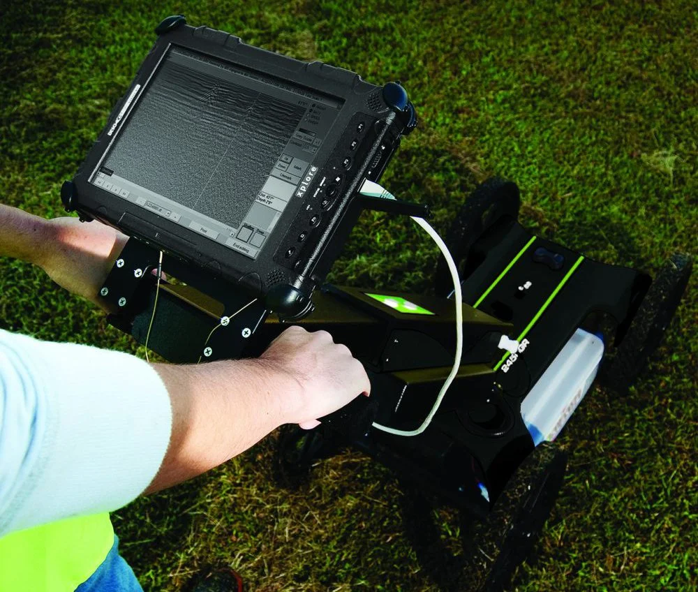
Ground penetrating radar (GPR) services offer a reliable method for detecting and mapping subsurface features. Using state-of-the-art technology, these services provide essential data that can help avoid costly damages and delays in construction and excavation projects. GPR is a non-invasive tool that uses electromagnetic waves to create images of underground structures, making it possible to locate utilities, pipelines, and other buried objects.
The accuracy of GPR services is pivotal for the integrity of your project, allowing for informed decision-making. GPR provides site analysis and mapping of existing underground infrastructure contributing to a more clear understanding of unseen utilities, structures, and the presence of any subsurface anomalies.
Fundamentals of Ground Penetrating Radar

In exploring the capabilities of ground penetrating radar (GPR), you'll discover a technology that employs electromagnetic energy to image subsurface features. This section will guide you through its basic technology and how it operates.
Technology Overview
GPR is a non-destructive tool that sends high-frequency electromagnetic waves into the ground. Ground penetrating radar systems are composed of a control unit, power supply, antenna, and data recording unit. The technology's flexibility allows it to be used over a variety of media, including soil, rock, and concrete.
Operational Principles
When operating GPR, electromagnetic pulses are transmitted into the ground and reflected back to the receiver. The pulses propagate until they encounter material boundaries with different dielectric properties. The key to capturing high-resolution data lies in the system's ability to detect these subtle changes, which arise due to variations in moisture content, material composition, or voids.
Transmission of Pulse: High-frequency radio waves are emitted by a GPR antenna.
Reflection of Signal: When waves encounter a boundary with contrasting dielectric properties, they reflect back.
Reception of Echo: The antenna receives the reflected waves.
Data Interpretation: The time delay and signal strength provide information on the depth and characteristics of the subsurface features.
Accuracy in GPR results depends significantly on proper understanding of these principles.
Advantages of GPR
Choosing GPR offers several distinct advantages:
Non-invasive Approach: It allows you to examine the subsurface without physical disruption.
Safety: As GPR does not require digging, it minimizes the risk of damaging underground utilities or other important structures.
GPR Applications in Construction and Engineering
Ground Penetrating Radar (GPR) provides an essential service helping to detect subsurface structures and utilities.
Utility Locating
When you use GPR for utility locating, you're investing in a preventative measure to avoid costly repairs and delays. GPR allows you to:
Identify the location of underground utilities, such as water, gas, electrical, and sewer lines.
Identify the presence of underground utilities that are not detected by traditional utility locating methods.
Map out hidden pipes and conduits to guide excavation and drilling, protecting existing infrastructure.
Concrete Scanning
Concrete scanning with GPR is a critical step before any modification or coring of concrete structures. With this technology, you can:
Efficiently locate rebar, post-tension cables, and conduits within concrete.
Scan areas of interest to ensure drilling, cutting, or coring can be executed safely without compromising structural integrity.
GPR Service Implementation and Best Practices
Ground Penetrating Radar (GPR) services provide critical information for subsurface investigations. When you implement GPR, it is crucial to have the right tools, adhere strictly to safety protocols, and accurately interpret the collected data to ensure project success.
Equipment and Technology Selection
When choosing equipment for your GPR services, consider the specific application and anticipated subsurface challenges. Your equipment should have antennae suitable for the required penetration depth and resolution. Ensuring that technicians are trained in the latest GPR technology will bring an added layer of expertise to your projects.
Challenges and Limitations of GPR
When considering ground penetrating radar (GPR) services, you should be aware of several limitations that can impact the effectiveness of the surveys.
Depth and Resolution
Depth Limitations: The ability of GPR to penetrate the ground depends on the soil composition and the frequency of the radar waves. Higher frequencies detect finer details but have shallower penetration. Conversely, lower frequencies penetrate deeper but lose resolution.
Resolution Limitations: The resolution of GPR is inherently tied to the frequency used. While high resolution can be achieved, it may not be sufficient to detect small or closely spaced anomalies.
Environmental Factors
Dielectric Constants: The success of GPR in detecting subsurface features, including voids, metallic and non-metallic objects, heavily relies on contrasting dielectric constants. Uniform materials with few dielectric contrasts may present a challenge.
Environmental Constraints: Soil type, soil moisture, and the presence of conductive materials affect GPR's ability to generate accurate images. Conductive soils, for instance, can absorb the radar waves, thereby reducing penetration depth.
Interpretation and Cost
Accuracy and Interpretation: Reading GPR data requires expertise, as it can be complex and prone to misinterpretation. Correctly identifying the location and depth of detected features is not always straightforward.
Costs: GPR services may be costly, but the expense should be weighed against the benefits of non-intrusive surveying and the potential risks of undetected subsurface features.
By understanding these challenges, you'll be in a better position to gauge whether GPR is the right tool for your project's specific needs.